Dolores River
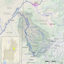
River in Colorado and Utah in the United StatesThe Dolores River is a tributary of the Colorado River, approximately 241 miles (388 km) long, in the U.S. states of Colorado and Utah. The river drains a rugged and arid region of the Colorado Plateau west of the San Juan Mountains. Its name derives from the Spanish El Rio de Nuestra Señora de Dolores, River of Our Lady of Sorrows. The river was explored and possibly named by Juan Maria Antonio Rivera during a 1765 expedition from Santa Fe.
Read article
Top Questions
AI generatedMore questions
Nearby Places
Dewey, Utah
Ghost town in Utah, United States


